The 7 day forecast for Lafayette from the Indianapolis NWS...
Today: Sunny, with a high near 47. West southwest wind between 5 and 11 mph.
Tonight: Mostly clear, with a low around 30. West wind between 6 and 10 mph.
Tuesday: Sunny, with a high near 54. West southwest wind between 3 and 8 mph.
Tuesday Night: Partly cloudy, with a low around 35. South southwest wind between 5 and 7 mph.
Wednesday: A 20 percent chance of showers. Mostly cloudy, with a high near 52. Light and variable wind.
Wednesday Night: A slight chance of rain before 1am, then a slight chance of rain and snow showers. Mostly cloudy, with a low around 28. Chance of precipitation is 20%.
Thursday: A chance of snow showers. Mostly cloudy, with a high near 30. Chance of precipitation is 30%.
Thursday Night: A chance of flurries. Mostly cloudy, with a low around 17.
Friday: Partly sunny, with a high near 24.
Friday Night: Mostly cloudy, with a low around 17.
Saturday: A chance of flurries. Mostly sunny, with a high near 31.
Saturday Night: Mostly cloudy, with a low around 22.
Sunday: Mostly sunny, with a high near 33.
Monday, January 9, 2012


Saturday, January 7, 2012
January 7th Almanac
Records for January 7th
Purdue Airport - LAF
High temperature: 69º in 2008
Low temperature: -13º in 1970
Precipitation: 0.59" in 1989
Snowfall: 1.8" in 1976
West Lafayette 6 NW COOP
High temperature: 67º in 2008
Low temperature: -14º in 1970
Precipitation: 1.94" in 1937
Snowfall: 4.0" in 2010
Purdue Airport - LAF
High temperature: 69º in 2008
Low temperature: -13º in 1970
Precipitation: 0.59" in 1989
Snowfall: 1.8" in 1976
West Lafayette 6 NW COOP
High temperature: 67º in 2008
Low temperature: -14º in 1970
Precipitation: 1.94" in 1937
Snowfall: 4.0" in 2010
Friday, January 6, 2012
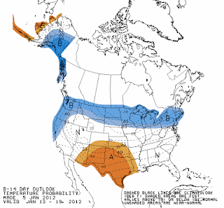
8-14 Day Outlook
Here's the temperature and precipitation maps from the Climate Prediction Center for the 8-14 day timeframe (January 13-19th).


Thursday, January 5, 2012
Pattern Change?
There is talk of a pattern change to more wintry conditions by the last week of January. Nothing is ever set in stone, but here's a look at the GFS ensemble mean temperature departure maps for three dates: January 6th, 13th, and 20th. Pay special attention to the large map on the left hand upper corner in western and central Canada. Notice how the warm departures get erased by the end of the run.


Wednesday, January 4, 2012
January 4th Almanac
Records for January 4th
Purdue Airport - LAF
High temperature: 66º in 1997
Low temperature: -9º in 1999
Precipitation: 1.54" in 1963
Snowfall: 3.0" in 1959
West Lafayette 6 NW COOP
High temperature: 61º in 1997
Low temperature: -16º in 1904
Precipitation: 1.96" in 1993
Snowfall: 1.5" in 1959
Purdue Airport - LAF
High temperature: 66º in 1997
Low temperature: -9º in 1999
Precipitation: 1.54" in 1963
Snowfall: 3.0" in 1959
West Lafayette 6 NW COOP
High temperature: 61º in 1997
Low temperature: -16º in 1904
Precipitation: 1.96" in 1993
Snowfall: 1.5" in 1959
Monday, January 2, 2012
Winter For The Next Two Days
There hasn't been much wintry weather so far this season...but for today and tomorrow it'll at least feel like it. Temperatures will rise thereafter, as the warmth takes hold again for the foreseeable future.
The forecast for Lafayette for today and tomorrow from the NWS...
Today: Scattered snow showers. Cloudy, with a temperature falling to around 21 by 5pm. Blustery, with a northwest wind around 22 mph, with gusts as high as 34 mph. Chance of precipitation is 30%.
Tonight: Scattered flurries before midnight. Cloudy, then gradually becoming partly cloudy, with a low around 11. Wind chill values as low as -1. Blustery, with a northwest wind between 15 and 21 mph, with gusts as high as 30 mph.
Tuesday: Mostly sunny, with a high near 25. Wind chill values as low as -1. West northwest wind between 8 and 11 mph.
The forecast for Lafayette for today and tomorrow from the NWS...
Today: Scattered snow showers. Cloudy, with a temperature falling to around 21 by 5pm. Blustery, with a northwest wind around 22 mph, with gusts as high as 34 mph. Chance of precipitation is 30%.
Tonight: Scattered flurries before midnight. Cloudy, then gradually becoming partly cloudy, with a low around 11. Wind chill values as low as -1. Blustery, with a northwest wind between 15 and 21 mph, with gusts as high as 30 mph.
Tuesday: Mostly sunny, with a high near 25. Wind chill values as low as -1. West northwest wind between 8 and 11 mph.
Sunday, January 1, 2012
Windy Today
The Indianapolis NWS office has us under a Wind Advisory for today until 10:00PM. Wind gusts to 50 MPH are possible. The winds have already gusted to 46 MPH at the Purdue Airport-LAF this morning.
Here's the text of the Wind Advisory:
Here's the text of the Wind Advisory:
URGENT - WEATHER MESSAGE
NATIONAL WEATHER SERVICE INDIANAPOLIS IN
1010 AM EST SUN JAN 1 2012

...VERY WINDY CONDITIONS TO BEGIN THE NEW YEAR...

.VERY STRONG WINDS ARE OCCURRING TODAY IN THE WAKE OF A STRONG
COLD FRONTAL PASSAGE. WESTERLY WINDS OF 25 TO 30 MPH WITH GUSTS OF
50 MPH CAN BE EXPECTED. THE STRONGEST WIND GUSTS WILL LIKELY OCCUR
THIS AFTERNOON ALONG AND NORTH OF INTERSTATE 70.

INZ021-028>031-035>049-051>057-060>065-067>072-012315-
/O.CON.KIND.WI.Y.0007.000000T0000Z-120102T0300Z/
CARROLL-WARREN-TIPPECANOE-CLINTON-HOWARD-FOUNTAIN-MONTGOMERY-
BOONE-TIPTON-HAMILTON-MADISON-DELAWARE-RANDOLPH-VERMILLION-PARKE-
PUTNAM-HENDRICKS-MARION-HANCOCK-HENRY-VIGO-CLAY-OWEN-MORGAN-
JOHNSON-SHELBY-RUSH-SULLIVAN-GREENE-MONROE-BROWN-BARTHOLOMEW-
DECATUR-KNOX-DAVIESS-MARTIN-LAWRENCE-JACKSON-JENNINGS-
INCLUDING THE CITIES OF...LAFAYETTE...FRANKFORT...KOKOMO...
CRAWFORDSVILLE...ANDERSON...MUNCIE...INDIANAPOLIS...TERRE HAUTE...
SHELBYVILLE...BLOOMINGTON...COLUMBUS...VINCENNES...BEDFORD...
SEYMOUR
1010 AM EST SUN JAN 1 2012

...WIND ADVISORY REMAINS IN EFFECT UNTIL 10 PM EST THIS EVENING...

A WIND ADVISORY REMAINS IN EFFECT UNTIL 10 PM EST THIS EVENING.

* WINDS: WINDS WILL INCREASE TO 30 MPH WITH GUSTS UP TO 50 MPH.
  THE STRONGEST WIND GUSTS WILL OCCUR THIS AFTERNOON...
  ESPECIALLY ALONG AND NORTH OF INTERSTATE 70. SOME LOCAL HIGHER
  WIND SPEEDS ARE POSSIBLE.

* IMPACTS: HOLIDAY TRAVELERS ON NORTH SOUTH ROADS WILL
  EXPERIENCE STRONG CROSS WINDS MAKING TRAVEL DIFFICULT. MINOR
  DAMAGE TO A FEW TREES AND POWER LINES ARE ALSO LIKELY.

PRECAUTIONARY/PREPAREDNESS ACTIONS...

A WIND ADVISORY MEANS THAT SUSTAINED WINDS OF 30 TO 39 MPH OR
WIND GUSTS FROM 45 TO 57 MPH ARE EXPECTED. WINDS THIS STRONG CAN
MAKE DRIVING DIFFICULT...ESPECIALLY FOR HIGH PROFILE VEHICLES.
USE EXTRA CAUTION.
Subscribe to:
Posts (Atom)