The first three days of this week look to be in the 50's...well above normal. Thereafter, a slow cool down commences. The forecast for Lafayette from the NWS...
Today: Mostly cloudy, with a high near 50. Breezy, with a south southwest wind between 16 and 20 mph, with gusts as high as 30 mph.
Tonight: Partly cloudy, with a low around 40. South southwest wind between 15 and 17 mph, with gusts as high as 26 mph.
Tuesday: Mostly sunny, with a high near 57. Breezy, with a south southwest wind between 14 and 20 mph, with gusts as high as 32 mph.
Tuesday Night: Rain likely. Mostly cloudy, with a low around 43. Southwest wind between 10 and 16 mph, with gusts as high as 23 mph. Chance of precipitation is 60%. New rainfall amounts of less than a tenth of an inch possible.
Wednesday: Mostly sunny, with a high near 51. West northwest wind around 8 mph.
Wednesday Night: Partly cloudy, with a low around 33.
Thursday: Partly sunny, with a high near 43.
Thursday Night: Partly cloudy, with a low around 31.
Friday: Partly sunny, with a high near 44.
Friday Night: A 30 percent chance of snow. Mostly cloudy, with a low around 30.
Saturday: A 30 percent chance of snow. Mostly cloudy, with a high near 38.
Saturday Night: A 30 percent chance of snow. Mostly cloudy, with a low around 27.
Sunday: Mostly sunny, with a high near 36.
Monday, January 30, 2012
Friday, January 27, 2012
Snow Late Tonight/Overnight
A small disturbance will bring a chance of snow late tonight and overnight. Amounts look to be on the light side, as anything over an inch would be surprise to me. Shouldn't be a big deal, but a covering of snow looks to be in the works.
Wednesday, January 25, 2012
Winter Weather Advisory In Effect
URGENT - WINTER WEATHER MESSAGE
NATIONAL WEATHER SERVICE INDIANAPOLIS IN
231 PM EST WED JAN 25 2012

...WINTER WEATHER ADVISORY THIS AFTERNOON INTO THURSDAY MORNING...

.WINTRY MIX TO IMPACT THE NORTHERN HALF OF CENTRAL INDIANA THIS
AFTERNOON INTO THURSDAY MORNING. THIS WILL BE CAUSED BY DEVELOPING
LOW PRESSURE TO THE SOUTHWEST OF THE AREA.

INZ021-028>031-035>049-051-052-260345-
/O.NEW.KIND.WW.Y.0003.120125T1931Z-120126T1500Z/
CARROLL-WARREN-TIPPECANOE-CLINTON-HOWARD-FOUNTAIN-MONTGOMERY-
BOONE-TIPTON-HAMILTON-MADISON-DELAWARE-RANDOLPH-VERMILLION-PARKE-
PUTNAM-HENDRICKS-MARION-HANCOCK-HENRY-VIGO-CLAY-
INCLUDING THE CITIES OF...LAFAYETTE...FRANKFORT...KOKOMO...
CRAWFORDSVILLE...ANDERSON...MUNCIE...INDIANAPOLIS...TERRE HAUTE
231 PM EST WED JAN 25 2012

...WINTER WEATHER ADVISORY IN EFFECT UNTIL 10 AM EST THURSDAY...

THE NATIONAL WEATHER SERVICE IN INDIANAPOLIS HAS ISSUED A WINTER
WEATHER ADVISORY FOR MINOR ACCUMULATIONS OF LIGHT FREEZING RAIN...
SLEET... AND LIGHT SNOW...UNTIL 10 AM EST THURSDAY.

* MAIN IMPACT: ROADS AND SIDEWALKS MAY BECOME SLIPPERY TO FREEZING
  RAIN...SLEET...AND SNOW. TRAVEL MAY BECOME DIFFICULT.

* ACCUMULATIONS: LIGHT ICING.

* TIMING: WEDNESDAY AFTERNOON THROUGH 10 AM THURSDAY MORNING.

* OTHER IMPACTS: VISIBILITIES MAY BE REDUCED.

PRECAUTIONARY/PREPAREDNESS ACTIONS...

A WINTER WEATHER ADVISORY MEANS THAT PERIODS OF SNOW...SLEET...OR
FREEZING RAIN WILL CAUSE TRAVEL DIFFICULTIES. BE PREPARED FOR
SLIPPERY ROADS AND LIMITED VISIBILITIES...AND USE CAUTION WHILE
Sunday, January 22, 2012
Severe Weather Threat Tonight
The Storm Prediction Center has Lafayette under a slight risk for severe weather late tonight. Main threat is damaging winds in a fast moving squall line.
Day 1 outlook: http://www.spc.noaa.gov/products/outlook/day1otlk.html
Day 1 outlook: http://www.spc.noaa.gov/products/outlook/day1otlk.html
January 21, 2012 Data
January 21st data at LAF
High temperature: 23º at 3:59PM
Low temperature: 15º at 8:54AM
Precipitation: 0.01"
Snowfall: 0.1"
Highest wind gust: 21 MPH
High temperature: 23º at 3:59PM
Low temperature: 15º at 8:54AM
Precipitation: 0.01"
Snowfall: 0.1"
Highest wind gust: 21 MPH
Saturday, January 21, 2012
Warm Up Tomorrow, Possible Thunderstorms Late Sun/Early Mon
The forecast for Lafayette from the NWS for Sunday and Monday.
Sunday: A 20 percent chance of showers after 1pm. Mostly cloudy, with a high near 46. Southeast wind between 7 and 14 mph, with gusts as high as 20 mph.
Sunday Night: Showers and thunderstorms. Low around 38. South wind between 15 and 17 mph, with gusts as high as 23 mph. Chance of precipitation is 90%. New rainfall amounts between a quarter and half of an inch possible.
Monday: A chance of rain showers before 1pm, then a slight chance of rain and snow showers. Cloudy, with a high near 38. Breezy, with a west southwest wind between 15 and 23 mph, with gusts as high as 32 mph. Chance of precipitation is 30%.
January 20, 2012 Data
January 20th data at LAF
High temperature: 19º at 11:59PM
Low temperature: -1º at 2:16AM
Precipitation: 0.13"
Snowfall: 3.1"
Highest wind gust: 29 MPH
High temperature: 19º at 11:59PM
Low temperature: -1º at 2:16AM
Precipitation: 0.13"
Snowfall: 3.1"
Highest wind gust: 29 MPH
Friday, January 20, 2012
Winter Weather Advisory In Effect
The NWS in Indianapolis has Lafayette under a Winter Weather Advisory in effect from 4PM tonight until 5AM Saturday. Total snowfall of around 3" looks possible. Advisory text below:
URGENT - WINTER WEATHER MESSAGE
NATIONAL WEATHER SERVICE INDIANAPOLIS IN
353 AM EST FRI JAN 20 2012

...WINTER WEATHER TO RETURN TO CENTRAL INDIANA LATE THIS AFTERNOON
AND EVENING...

.A QUICK MOVING AREA OF LOW PRESSURE IS EXPECTED TO PUSH INTO THE
OHIO VALLEY LATE THIS AFTERNOON AND EVENING. VERY COLD AIR WILL BE
IN PLACE AHEAD OF THE LOW TODAY AND THIS WILL BE KEY AS WARMER AIR
WILL BE PUSHED INTO CENTRAL INDIANA AHEAD OF THE LOW...RESULTING
IN MIXED PRECIPITATION. FREEZING RAIN OR SLEET IS EXPECTED TO
DEVELOP LATE THIS AFTERNOON AND THIS EVENING MAINLY ALONG AND
SOUTH OF INTERSTATE 70...AFFECTING INDIANAPOLIS...TERRE
HAUTE...NEW CASTLE...BLOOMINGTON...COLUMBUS...SEYMOUR AND VINCENNES.

COLD AIR IN PLACE ACROSS NORTHERN PARTS OF CENTRAL INDIANA WILL
RESULT IN AREAS LIKE KOKOMO...LAFAYETTE...ANDERSON AND MUNCIE
RECEIVING ONLY SNOW. HOWEVER AROUND 3 INCHES OF ACCUMULATION WILL
BE POSSIBLE.

INZ021-028>031-035>049-051>057-060>065-067>072-201700-
/O.NEW.KIND.WW.Y.0002.120120T2100Z-120121T1000Z/
CARROLL-WARREN-TIPPECANOE-CLINTON-HOWARD-FOUNTAIN-MONTGOMERY-
BOONE-TIPTON-HAMILTON-MADISON-DELAWARE-RANDOLPH-VERMILLION-PARKE-
PUTNAM-HENDRICKS-MARION-HANCOCK-HENRY-VIGO-CLAY-OWEN-MORGAN-
JOHNSON-SHELBY-RUSH-SULLIVAN-GREENE-MONROE-BROWN-BARTHOLOMEW-
DECATUR-KNOX-DAVIESS-MARTIN-LAWRENCE-JACKSON-JENNINGS-
INCLUDING THE CITIES OF...LAFAYETTE...FRANKFORT...KOKOMO...
CRAWFORDSVILLE...ANDERSON...MUNCIE...INDIANAPOLIS...TERRE HAUTE...
SHELBYVILLE...BLOOMINGTON...COLUMBUS...VINCENNES...BEDFORD...
SEYMOUR
353 AM EST FRI JAN 20 2012

...WINTER WEATHER ADVISORY IN EFFECT FROM 4 PM THIS AFTERNOON TO
5 AM EST SATURDAY...

THE NATIONAL WEATHER SERVICE IN INDIANAPOLIS HAS ISSUED A WINTER
WEATHER ADVISORY FOR SNOW...FREEZING RAIN AND SLEET...WHICH IS IN
EFFECT FROM 4 PM THIS AFTERNOON TO 5 AM EST SATURDAY.

* MAIN IMPACT: ROADS MAY BECOME SLIPPERY TO SNOW...FREEZING RAIN
  OR SLEET. TRAVEL MAY BECOME DIFFICULT.

* ACCUMULATIONS: SNOW ACCUMULATIONS AROUND 3 INCHES ARE POSSIBLE
  IN THE LAFAYETTE...KOKOMO...MUNICE AND ANDERSON AREA. LESSER
  SNOW AND SLEET ACCUMULATIONS...MIXING WITH ICE ACCUMULATIONS
  AROUND ONE TO TWO TENTHS OF AN INCH WILL BE POSSIBLE ACROSS THE
  INDIANAPOLIS...TERRE HAUTE...BLOOMINGTON...NEW CASTLE...SEYMOUR
  AND COLUMBUS AREAS.

* TIMING: PRECIPITATION IS EXPECTED TO BEGIN LATE THIS
  AFTERNOON...IN TIME FOR THE AFTERNOON RUSH HOURS. MIXED
  PRECIPITATION SHOULD CHANGE OVER TO ALL SNOW BY MIDNIGHT AND
  ACCUMULATING SNOWS SHOW END BY 5 AM SATURDAY.

* OTHER IMPACTS: ROADS AND SURFACES WILL BE SLIPPERY. DRIVING MAY
  BECOME DIFFICULT OR HAZARDOUS. USE EXTRA CAUTION IF YOU DECIDE
  TO DRIVE LATE THIS AFTERNOON AND THE EVENING...AND ALLOW EXTRA
  TIME TO REACH YOUR DESTINATION.

PRECAUTIONARY/PREPAREDNESS ACTIONS...

A WINTER WEATHER ADVISORY MEANS THAT PERIODS OF SNOW...SLEET...OR
FREEZING RAIN WILL CAUSE TRAVEL DIFFICULTIES. BE PREPARED FOR
SLIPPERY ROADS AND LIMITED VISIBILITIES...AND USE CAUTION WHILE
DRIVING.

&&

$$

PUMA
January 19, 2012 Data
January 19th data at LAF
High temperature: 31º at 8:40AM
Low temperature: 3º at 11:55PM
Precipitation: 0.04"
Snowfall: 3.5"
Highest wind gust: 28 MPH
High temperature: 31º at 8:40AM
Low temperature: 3º at 11:55PM
Precipitation: 0.04"
Snowfall: 3.5"
Highest wind gust: 28 MPH
Thursday, January 19, 2012
Snow Today, Mixed Bag Tomorrow
Radars are filling in quite nicely this morning, as it has already started snowing in Lafayette. Looks like 1-2" could fall, with isolated higher amounts.
Tomorrow, another system makes it way towards Lafayette. Details are sketchy at this point, but it could be a mixed bag of precipitation...though not heavy amounts of anything.
Tomorrow, another system makes it way towards Lafayette. Details are sketchy at this point, but it could be a mixed bag of precipitation...though not heavy amounts of anything.
January 18, 2012 Data
January 18th data at LAF
High temperature: 29º at 4:56PM
Low temperature: 15º at 8:09AM
Precipitation: T
Snowfall: T
Highest wind gust: 26 MPH
High temperature: 29º at 4:56PM
Low temperature: 15º at 8:09AM
Precipitation: T
Snowfall: T
Highest wind gust: 26 MPH
Wednesday, January 18, 2012
Snow On Thursday?
Looks like some light snow will develop tomorrow morning. At this point, anywhere from a dusting to, at best, an inch of snow could fall. More wintry precipitation is on tap for Friday...stay tuned.
January 17, 2012 Data
January 17th data at LAF
High temperature: 59º at 1:16AM
Low temperature: 25º at 11:59PM
Precipitation: 1.46"
Snowfall: Trace
Highest wind gust: 41 MPH
High temperature: 59º at 1:16AM
Low temperature: 25º at 11:59PM
Precipitation: 1.46"
Snowfall: Trace
Highest wind gust: 41 MPH
Tuesday, January 17, 2012
Wild Weather Overnight
Woke up around 4:00AM to pea size hail, gusty winds, and torrential rainfall. A total of 1.45" of rainfall was recorded at LAF. Spring was here overnight, but now temperatures are falling through the 30's with gusty winds.
Storm reports from overnight:
Storm reports from overnight:
0357 AM     HAIL             4 W WEST LAFAYETTE      40.44N 86.99W
01/17/2012  E0.25 INCH       TIPPECANOE         IN   TRAINED SPOTTER

            DOWNPOUR OF PEA SIZE HAIL LASTED A FEW MINUTES AND
            PARTIALLY COVERED THE GROUND.

0357 AM     HAIL             4 W WEST LAFAYETTE      40.44N 86.99W
01/17/2012  E0.25 INCH       TIPPECANOE         IN   TRAINED SPOTTER

            DOWNPOUR OF PEA SIZE HAIL WHICH PARTIALLY COVERED THE
            GROUND. LASTED A FEW MINUTES.

0404 AM     TSTM WND GST     LAFAYETTE               40.41N 86.87W
01/17/2012 M39.00 MPH TIPPECANOE IN ASOS
Sunday, January 15, 2012
Outlook For The Next 7 Days
Overall warm, but some cold shots. The forecast for Lafayette from the NWS:
Today: Mostly sunny, with a high near 32. South wind between 8 and 11 mph.
Tonight: Mostly clear, with a low around 28. South wind between 11 and 17 mph, with gusts as high as 25 mph.
M.L.King Day: A 50 percent chance of rain. Mostly cloudy, with a high near 43. South southwest wind between 15 and 18 mph, with gusts as high as 26 mph. New rainfall amounts of less than a tenth of an inch possible.
Monday Night: Rain. Low around 35. Southwest wind around 11 mph. Chance of precipitation is 80%. New rainfall amounts between a tenth and quarter of an inch possible.
Tuesday: A chance of rain and snow before 1pm, then a slight chance of snow. Mostly cloudy, with a high near 37. Northwest wind between 10 and 17 mph, with gusts as high as 25 mph. Chance of precipitation is 40%.
Tuesday Night: Partly cloudy, with a low around 14.
Wednesday: Mostly sunny, with a high near 26.
Wednesday Night: Partly cloudy, with a low around 20.
Thursday: A 30 percent chance of snow. Mostly cloudy, with a high near 32.
Thursday Night: Mostly cloudy, with a low around 22.
Friday: A 40 percent chance of rain. Mostly cloudy, with a high near 38.
Friday Night: A chance of rain and snow. Mostly cloudy, with a low around 29. Chance of precipitation is 30%.
Saturday: Partly sunny, with a high near 40.
Friday, January 13, 2012
Recent Snowfall Totals
Via the local CoCoRaHS observers.
Lafayette 2.2 S: 4.0"
Lafayette 2.2 NE: 4.0"
West Lafayette 5.1 WSW: 3.6"
Lafayette 2.2 S: 4.0"
Lafayette 2.2 NE: 4.0"
West Lafayette 5.1 WSW: 3.6"
Wednesday, January 11, 2012
Winter Weather Advisory In Effect
The Indianapolis NWS office has issued a Winter Weather Advisory from 10:00AM tomorrow until 1:00PM Friday. Text below:
URGENT - WINTER WEATHER MESSAGE
NATIONAL WEATHER SERVICE INDIANAPOLIS IN
339 PM EST WED JAN 11 2012

...WINTER WEATHER ADVISORY IN EFFECT FROM 10 AM THURSDAY TO 1 PM
EST FRIDAY...

.AN UPPER LEVEL LOW WILL BRING ACCUMULATING SNOW TO CENTRAL
INDIANA TOMORROW THROUGH FRIDAY. NORTHWEST WINDS WILL BECOME
STRONG BEHIND THE SYSTEM RESULTING IN BLOWING SNOW THROUGH FRIDAY.
THIS WILL CAUSE DRIFTING AND REDUCED VISIBILITIES.

INZ021-028>031-035>049-051>057-060>065-067>072-120445-
/O.NEW.KIND.WW.Y.0001.120112T1500Z-120113T1800Z/
CARROLL-WARREN-TIPPECANOE-CLINTON-HOWARD-FOUNTAIN-MONTGOMERY-
BOONE-TIPTON-HAMILTON-MADISON-DELAWARE-RANDOLPH-VERMILLION-PARKE-
PUTNAM-HENDRICKS-MARION-HANCOCK-HENRY-VIGO-CLAY-OWEN-MORGAN-
JOHNSON-SHELBY-RUSH-SULLIVAN-GREENE-MONROE-BROWN-BARTHOLOMEW-
DECATUR-KNOX-DAVIESS-MARTIN-LAWRENCE-JACKSON-JENNINGS-
INCLUDING THE CITIES OF...LAFAYETTE...FRANKFORT...KOKOMO...
CRAWFORDSVILLE...ANDERSON...MUNCIE...INDIANAPOLIS...TERRE HAUTE...
SHELBYVILLE...BLOOMINGTON...COLUMBUS...VINCENNES...BEDFORD...
SEYMOUR
339 PM EST WED JAN 11 2012

...WINTER WEATHER ADVISORY IN EFFECT FROM 10 AM THURSDAY TO 1 PM
EST FRIDAY...

THE NATIONAL WEATHER SERVICE IN INDIANAPOLIS HAS ISSUED A WINTER
WEATHER ADVISORY FOR SNOW...WHICH IS IN EFFECT FROM 10 AM THURSDAY
TO 1 PM EST FRIDAY.

* TIMING...THURSDAY AFTERNOON THROUGH EARLY FRIDAY MORNING.

* MAIN IMPACT...SLIPPERY ROADS DURING THURSDAY EVENING AND FRIDAY
  MORNING RUSH HOURS.

* OTHER IMPACTS...BLOWING SNOW WILL RESULT IN DRIFTING AND REDUCED VISIBILITIES.

* ACCUMULATIONS...3 TO 5 INCHES ACROSS THE NORTHERN COUNTIES/2 TO
  4 INCHES ACROSS THE CENTRAL PORTIONS OF CENTRAL INDIANA/1 TO 3
  INCHES ACROSS THE SOUTHERN COUNTIES.

PRECAUTIONARY/PREPAREDNESS ACTIONS...

A WINTER WEATHER ADVISORY FOR SNOW MEANS THAT PERIODS OF SNOW
WILL CAUSE PRIMARILY TRAVEL DIFFICULTIES. BE PREPARED FOR SNOW
COVERED ROADS AND LIMITED VISIBILITIES...AND USE CAUTION WHILE
DRIVING.


A WINTER WEATHER ADVISORY FOR BLOWING SNOW MEANS THAT
VISIBILITIES WILL BE LIMITED DUE TO STRONG WINDS BLOWING SNOW
AROUND. USE CAUTION WHEN TRAVELING...ESPECIALLY IN OPEN AREAS.


&&

$$

TDUD
Snowfall Totals For Thursday-Friday
Here are two total snowfall maps from two of the most recent weather model runs. LAF basically falls anywhere from 2-6" depending on which one you want to believe. I think a safe range at this point is 2-4", with locally higher amounts possible. Again, gusty winds to or above 30 MPH will make for low visibilities at times. Use caution if traveling tomorrow afternoon and evening.


Tuesday, January 10, 2012
Possible Snow Thursday And Friday
After a bit of rain tomorrow night, looks like a frontal system will sweep in and produce some snow for Lafayette on Thursday and Friday. While snow amounts don't look heavy (thinking a range between 1-3" right now), the combination of snow falling with winds gusting to 30MPH could reduce visibilities at times. Hopefully we get a better idea of potential snowfall amounts by tomorrow.
Monday, January 9, 2012
Spring...And Then Winter
The 7 day forecast for Lafayette from the Indianapolis NWS...
Today: Sunny, with a high near 47. West southwest wind between 5 and 11 mph.
Tonight: Mostly clear, with a low around 30. West wind between 6 and 10 mph.
Tuesday: Sunny, with a high near 54. West southwest wind between 3 and 8 mph.
Tuesday Night: Partly cloudy, with a low around 35. South southwest wind between 5 and 7 mph.
Wednesday: A 20 percent chance of showers. Mostly cloudy, with a high near 52. Light and variable wind.
Wednesday Night: A slight chance of rain before 1am, then a slight chance of rain and snow showers. Mostly cloudy, with a low around 28. Chance of precipitation is 20%.
Thursday: A chance of snow showers. Mostly cloudy, with a high near 30. Chance of precipitation is 30%.
Thursday Night: A chance of flurries. Mostly cloudy, with a low around 17.
Friday: Partly sunny, with a high near 24.
Friday Night: Mostly cloudy, with a low around 17.
Saturday: A chance of flurries. Mostly sunny, with a high near 31.
Saturday Night: Mostly cloudy, with a low around 22.
Sunday: Mostly sunny, with a high near 33.
Saturday, January 7, 2012
January 7th Almanac
Records for January 7th
Purdue Airport - LAF
High temperature: 69º in 2008
Low temperature: -13º in 1970
Precipitation: 0.59" in 1989
Snowfall: 1.8" in 1976
West Lafayette 6 NW COOP
High temperature: 67º in 2008
Low temperature: -14º in 1970
Precipitation: 1.94" in 1937
Snowfall: 4.0" in 2010
Purdue Airport - LAF
High temperature: 69º in 2008
Low temperature: -13º in 1970
Precipitation: 0.59" in 1989
Snowfall: 1.8" in 1976
West Lafayette 6 NW COOP
High temperature: 67º in 2008
Low temperature: -14º in 1970
Precipitation: 1.94" in 1937
Snowfall: 4.0" in 2010
Friday, January 6, 2012
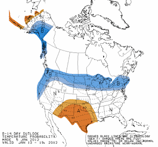
8-14 Day Outlook
Here's the temperature and precipitation maps from the Climate Prediction Center for the 8-14 day timeframe (January 13-19th).


Thursday, January 5, 2012
Pattern Change?
There is talk of a pattern change to more wintry conditions by the last week of January. Nothing is ever set in stone, but here's a look at the GFS ensemble mean temperature departure maps for three dates: January 6th, 13th, and 20th. Pay special attention to the large map on the left hand upper corner in western and central Canada. Notice how the warm departures get erased by the end of the run.


Wednesday, January 4, 2012
January 4th Almanac
Records for January 4th
Purdue Airport - LAF
High temperature: 66º in 1997
Low temperature: -9º in 1999
Precipitation: 1.54" in 1963
Snowfall: 3.0" in 1959
West Lafayette 6 NW COOP
High temperature: 61º in 1997
Low temperature: -16º in 1904
Precipitation: 1.96" in 1993
Snowfall: 1.5" in 1959
Purdue Airport - LAF
High temperature: 66º in 1997
Low temperature: -9º in 1999
Precipitation: 1.54" in 1963
Snowfall: 3.0" in 1959
West Lafayette 6 NW COOP
High temperature: 61º in 1997
Low temperature: -16º in 1904
Precipitation: 1.96" in 1993
Snowfall: 1.5" in 1959
Monday, January 2, 2012
Winter For The Next Two Days
There hasn't been much wintry weather so far this season...but for today and tomorrow it'll at least feel like it. Temperatures will rise thereafter, as the warmth takes hold again for the foreseeable future.
The forecast for Lafayette for today and tomorrow from the NWS...
Today: Scattered snow showers. Cloudy, with a temperature falling to around 21 by 5pm. Blustery, with a northwest wind around 22 mph, with gusts as high as 34 mph. Chance of precipitation is 30%.
Tonight: Scattered flurries before midnight. Cloudy, then gradually becoming partly cloudy, with a low around 11. Wind chill values as low as -1. Blustery, with a northwest wind between 15 and 21 mph, with gusts as high as 30 mph.
Tuesday: Mostly sunny, with a high near 25. Wind chill values as low as -1. West northwest wind between 8 and 11 mph.
Sunday, January 1, 2012
Windy Today
The Indianapolis NWS office has us under a Wind Advisory for today until 10:00PM. Wind gusts to 50 MPH are possible. The winds have already gusted to 46 MPH at the Purdue Airport-LAF this morning.
Here's the text of the Wind Advisory:
Here's the text of the Wind Advisory:
URGENT - WEATHER MESSAGE
NATIONAL WEATHER SERVICE INDIANAPOLIS IN
1010 AM EST SUN JAN 1 2012

...VERY WINDY CONDITIONS TO BEGIN THE NEW YEAR...

.VERY STRONG WINDS ARE OCCURRING TODAY IN THE WAKE OF A STRONG
COLD FRONTAL PASSAGE. WESTERLY WINDS OF 25 TO 30 MPH WITH GUSTS OF
50 MPH CAN BE EXPECTED. THE STRONGEST WIND GUSTS WILL LIKELY OCCUR
THIS AFTERNOON ALONG AND NORTH OF INTERSTATE 70.

INZ021-028>031-035>049-051>057-060>065-067>072-012315-
/O.CON.KIND.WI.Y.0007.000000T0000Z-120102T0300Z/
CARROLL-WARREN-TIPPECANOE-CLINTON-HOWARD-FOUNTAIN-MONTGOMERY-
BOONE-TIPTON-HAMILTON-MADISON-DELAWARE-RANDOLPH-VERMILLION-PARKE-
PUTNAM-HENDRICKS-MARION-HANCOCK-HENRY-VIGO-CLAY-OWEN-MORGAN-
JOHNSON-SHELBY-RUSH-SULLIVAN-GREENE-MONROE-BROWN-BARTHOLOMEW-
DECATUR-KNOX-DAVIESS-MARTIN-LAWRENCE-JACKSON-JENNINGS-
INCLUDING THE CITIES OF...LAFAYETTE...FRANKFORT...KOKOMO...
CRAWFORDSVILLE...ANDERSON...MUNCIE...INDIANAPOLIS...TERRE HAUTE...
SHELBYVILLE...BLOOMINGTON...COLUMBUS...VINCENNES...BEDFORD...
SEYMOUR
1010 AM EST SUN JAN 1 2012

...WIND ADVISORY REMAINS IN EFFECT UNTIL 10 PM EST THIS EVENING...

A WIND ADVISORY REMAINS IN EFFECT UNTIL 10 PM EST THIS EVENING.

* WINDS: WINDS WILL INCREASE TO 30 MPH WITH GUSTS UP TO 50 MPH.
  THE STRONGEST WIND GUSTS WILL OCCUR THIS AFTERNOON...
  ESPECIALLY ALONG AND NORTH OF INTERSTATE 70. SOME LOCAL HIGHER
  WIND SPEEDS ARE POSSIBLE.

* IMPACTS: HOLIDAY TRAVELERS ON NORTH SOUTH ROADS WILL
  EXPERIENCE STRONG CROSS WINDS MAKING TRAVEL DIFFICULT. MINOR
  DAMAGE TO A FEW TREES AND POWER LINES ARE ALSO LIKELY.

PRECAUTIONARY/PREPAREDNESS ACTIONS...

A WIND ADVISORY MEANS THAT SUSTAINED WINDS OF 30 TO 39 MPH OR
WIND GUSTS FROM 45 TO 57 MPH ARE EXPECTED. WINDS THIS STRONG CAN
MAKE DRIVING DIFFICULT...ESPECIALLY FOR HIGH PROFILE VEHICLES.
USE EXTRA CAUTION.
Subscribe to:
Posts (Atom)